Survey Services for Construction Projects: Avoiding Costly Mistakes
Why Survey Services Are Essential for Construction Projects
Professional land surveyors help construction projects avoid costly mistakes through accurate survey data. From small residential extensions to major civil engineering schemes, a comprehensive topographical survey provides the detailed information architects, contractors, and developers need to plan and execute work safely, on budget, and without unexpected delays.
Construction projects in the UK face increasing regulatory requirements and rising material costs. Getting a topographical survey before breaking ground isn't just recommended—it's essential. Accurate land data helps prevent unforeseen issues that can derail timelines, blow budgets, and create legal liabilities. Whether you're building a new home, extending a commercial property, or managing a large-scale development project, understanding the importance of topographic surveys is the first step toward success.
The Real Cost of Construction Mistakes
Construction mistakes are expensive. A Royal Institution of Chartered Surveyors (RICS) study found that poor site preparation and inadequate survey data contribute to nearly 40% of project delays and cost overruns in UK construction. These delays aren't minor—they can add weeks or months to schedules and thousands of pounds to budgets.
Common Costly Mistakes That Professional Surveys Prevent
- Unexpected Underground Utilities: Striking buried water mains, gas pipes, or electricity cables can halt work immediately, incur emergency repair costs, and create serious safety hazards. A measured survey with utility mapping identifies these risks before excavation begins.
- Drainage and Flood Issues: Building on poorly drained land or in flood-prone areas without adequate planning leads to subsidence, flooding, and structural damage. Topographic data including spot levels and contour lines reveals natural water flow patterns.
- Boundary Disputes: Encroaching on neighboring property causes legal disputes that can stop construction entirely. Accurate GPS equipment and total station measurements establish precise boundaries.
- Inadequate Foundation Design: Without understanding soil conditions, elevation changes, and existing ground levels, foundation designs may be inadequate, leading to settlement issues or structural failure.
- Planning Permission Rejections: Local authorities require detailed topographical survey data for planning applications. Incomplete or inaccurate survey results lead to rejections and costly resubmissions.
In one recent case study, a residential development in the Midlands proceeded without a proper topographical land survey. The project encountered unexpected clay soil conditions and underground springs that weren't visible in desktop surveys. The developer faced £120,000 in additional foundation work, a four-month delay, and renegotiations with buyers. A comprehensive survey would have cost £3,500—a fraction of the eventual overrun.
Types of Survey Services for Construction Projects
Different construction projects require different types of survey. Understanding which survey services you need ensures you get accurate data without paying for unnecessary work. Here's a breakdown of the most common types:
Topographic Survey
A topographic survey (also called a topo survey or topographical survey) is the foundation of most construction projects. It maps the natural and man-made features of a site, including elevation changes, buildings, trees, fences, drainage features, and spot levels. Surveyors use GPS equipment, total stations, and increasingly drone survey technology to capture detailed topographic data.
The deliverable is typically a CAD drawing showing contour lines, spot levels, and all relevant land features. Architects use these survey results to design buildings that work with the natural topography. Contractors rely on accurate survey data to plan grading, drainage, and site access.
Measured Building Survey
For refurbishment, extension, or conversion projects, a measured survey of existing structures is essential. This type of survey captures floor plans, elevations, and sections of buildings with millimeter accuracy. Architects need this level of detail to design extensions that integrate seamlessly with existing structures.
Modern measured surveys often incorporate laser scanning and 3D modeling, creating survey cloud data that allows architects to work in Building Information Modeling (BIM) environments. This technology reduces site visits and provides a permanent digital record of the structure.
Utility Mapping and Underground Survey
Knowing what's below ground is just as important as what's above. Utility mapping uses ground-penetrating radar (GPR), electromagnetic locators, and existing utility records to identify buried water mains, gas pipes, electricity cables, telecoms, and drainage systems. For construction projects involving excavation, this survey prevents catastrophic strikes on live services.
Boundary and Land Registry Survey
Establishing legal boundaries is critical before starting construction. A boundary survey references Ordnance Survey data and Land Registry title plans to mark precise property lines. This prevents disputes with neighbors and ensures your development project stays within your legal area of land.
The Survey Process: What to Expect
Understanding the survey process helps construction project managers plan timelines and budgets effectively. Here's what happens when you commission professional survey services:
1. Initial Consultation and Scope Definition
A professional topographical surveyor will discuss your project needs to determine the type of survey required, the level of detail needed, and any specific requirements for planning permission or architect drawings. This consultation ensures the survey provides exactly the data your project needs without unnecessary cost.
2. Desktop Study and Preparation
Before arriving on site, the survey team conducts desktop research using Ordnance Survey maps, utility company records, aerial imagery, and geological data. This preparation identifies potential issues and helps plan the most efficient survey methodology.
3. Site Survey and Data Collection
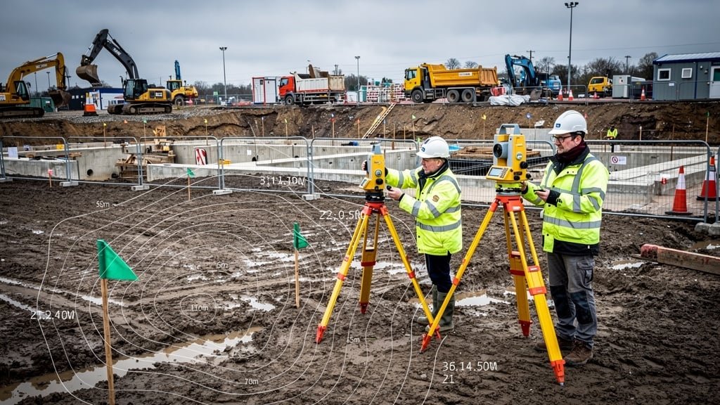
Using highly specialised survey equipment—total stations, accurate GPS equipment, laser scanners, or drones—the surveyor measures the site. Modern surveying technology allows teams to gather thousands of data points in a single day, capturing every relevant detail with millimeter precision. The survey gathers information on elevation, natural topographic features, existing structures, vegetation, and access points.
4. Data Processing and CAD Drawing Production
Raw survey data is processed using specialized CAD software to create detailed topographic survey plans. These drawings include contour lines showing elevation changes, spot levels at key points, and symbols representing all natural and man-made features. The final CAD drawings are typically delivered in multiple formats (DWG, DXF, PDF) to suit different users—architects, engineers, and planning officers.
5. Quality Assurance and Delivery
Accredited surveyors from professional bodies like RICS, CIOB, or the Royal Chartered Surveyor Association perform quality checks to ensure accuracy and completeness. The final survey results are delivered with supporting documentation, notes on methodology, and recommendations for the construction project.
How Accurate Survey Data Prevents Costly Mistakes
Accurate data is the cornerstone of successful construction projects. Here's how professional surveys provide the foundation for error-free building:
Avoiding Design Errors Before Construction Begins
When architects design on inaccurate or incomplete topographical survey data, the result is designs that don't fit the actual site conditions. This becomes apparent only when construction begins—by which point redesign and modification costs are substantial. A comprehensive topographic land survey gives architects an accurate picture of the land, allowing them to design buildings that work with natural topography rather than fighting against it.
Optimizing Earthworks and Grading
Earthmoving is one of the largest costs in site preparation. With accurate spot levels and contour data, contractors can calculate exact cut-and-fill volumes, minimizing the need to import or remove soil. This optimization can save tens of thousands of pounds on large development projects. Getting a topographical survey allows contractors to plan efficient grading that manages surface water drainage and creates stable building platforms.
Ensuring Structural Integrity
Foundation design depends on understanding ground levels, soil conditions, and water table depth. A detailed topographic survey may reveal slope instability, areas prone to settlement, or zones requiring special foundation treatment. Structural engineers use this survey data to design foundations that ensure long-term building stability.
Meeting Regulatory Requirements
Local authorities across the UK require detailed survey information for planning permission applications. Planning officers need to see how the proposed development relates to existing topography, neighboring properties, and natural features. A professional topographical survey provides the accurate land data needed to satisfy these requirements and avoid application rejections.
Modern Surveying Technology in Construction
Surveying technology has advanced dramatically in recent years, making surveys faster, more accurate, and more comprehensive than ever before. Modern topographical surveys leverage multiple technologies:
Drone Survey Capabilities
Unmanned aerial vehicles (UAVs) equipped with GPS, cameras, and laser scanners can survey large or difficult-to-access sites quickly and safely. A drone survey captures thousands of data points from above, creating detailed 3D models and orthophotography. This technology is particularly valuable for large land development projects, sites with difficult terrain, or areas with safety concerns.
3D Laser Scanning
Terrestrial laser scanners capture millions of measurement points in minutes, creating detailed survey cloud data that represents every surface, structure, and feature. This technology is ideal for complex buildings, heritage structures, or sites requiring extreme accuracy. The resulting 3D models integrate directly with BIM software used by architects and engineers.
GPS and Total Station Integration
Professional land surveyors combine GPS technology for positioning with total stations for precise angle and distance measurements. This integration delivers accuracy to within millimeters while referencing data to Ordnance Survey national grids. The result is survey data that aligns perfectly with planning maps and neighboring site surveys.
Choosing the Right Survey Company for Your Project
Not all survey companies offer the same quality or expertise. When selecting professional topographical surveyors for your construction project, consider these factors:
Accreditation and Professional Membership
Look for surveyors who are members of recognized professional bodies such as the Royal Institution of Chartered Surveyors (RICS), the Chartered Institution of Building (CIOB), or the Royal Chartered Surveyor Association (RPSA). These accreditations demonstrate commitment to professional standards, continuing education, and ethical practice.
Technology and Equipment
A reputable survey company invests in modern survey equipment and stays current with surveying technology. Ask about the equipment they use—accurate GPS equipment, total stations, laser scanners, and drones all indicate a professional operation capable of delivering precise results.
Experience with Similar Projects
Construction projects vary widely in complexity. A surveyor experienced with residential extensions may not be the best choice for large civil engineering projects, and vice versa. Ask for case studies or references from similar construction projects to ensure the survey team understands the specific survey needs of your project type.
Clear Communication and Deliverables
Professional surveyors clearly explain the survey process, timeline, and deliverables. They should specify the level of detail, format of CAD drawings, and any assumptions or limitations. This transparency ensures you receive survey data in the format your architect, engineer, and contractors need.
When to Commission Survey Services in Your Project Timeline
Timing is critical. Getting a topographical survey at the right stage ensures maximum value and avoids delays:
- Pre-Purchase Due Diligence: Before buying land for development, commission surveys to identify issues that might affect value or buildability.
- Feasibility Stage: Early topographic surveys help determine if a site is suitable for the proposed development before investing in detailed design.
- Planning Application: Surveys are typically required as part of planning submissions to local authorities.
- Detailed Design Phase: Architects and engineers need accurate survey data to create buildable designs.
- Pre-Construction: Update surveys if significant time has passed since the original survey to ensure accuracy.
Conclusion: Invest in Survey Services to Protect Your Construction Project
Survey services are not an optional luxury—they're an essential investment that protects your construction project from costly mistakes. Whether you're planning a small residential extension or a major commercial development, accurate topographical survey data provides the foundation for success. From preventing utility strikes and drainage failures to ensuring planning permission approval and structural integrity, professional surveys deliver value many times their cost.
The construction industry operates on tight margins, and there's little room for error. Unforeseen issues discovered mid-project can consume profits and damage reputations. By engaging accredited land surveyors early in your project timeline, you gain the accurate data, expert insights, and regulatory documentation needed to build confidently.
At Surveyor Topographer, we provide comprehensive survey services throughout the UK, using modern surveying technology and professional expertise to deliver the accurate land data your engineering and construction projects demand. Our topographical surveyors work with architects, developers, contractors, and homeowners to ensure construction projects proceed smoothly from design through completion.
Need a topographic survey for your next construction project? Don't let poor site data become a costly mistake. Contact our survey team today to discuss how professional survey services can protect your investment and ensure project success.
Ready to Avoid Costly Construction Mistakes?
Get professional survey services for your construction project. Contact our expert land surveyors today for a detailed quote.
Request a Survey Quote