How Drone Survey Technology is Revolutionizing Topographic Surveys
Modern drone survey technology is transforming how professional topographical surveyors conduct land surveys across the UK. What once took days or weeks to survey using traditional methods can now be completed in hours with unprecedented accuracy. This revolution in surveying technology is making topographic surveys faster, safer, and more cost-effective while delivering richer, more detailed survey data than ever before.
The Evolution of Survey Technology
To appreciate the impact of drone surveys, it's helpful to understand how land surveying has evolved. Traditional surveying methods using total stations and GPS equipment require surveyors to physically access every point being measured. This means walking across entire sites, often in challenging terrain, setting up equipment repeatedly, and manually recording thousands of measurements.
While these traditional methods remain valuable and accurate, they have limitations. Large sites can take weeks to survey completely. Difficult terrain—steep slopes, dense vegetation, or hazardous areas—can be dangerous or impossible to access. Weather delays are common, and the process is labor-intensive, making it relatively expensive for extensive areas.
Drone survey technology addresses these challenges by capturing data from above. Modern survey drones equipped with high-resolution cameras and precision GPS can photograph entire sites in a single flight, with software processing these images into detailed topographic maps, CAD drawings, and 3D models.
How Drone Surveys Work
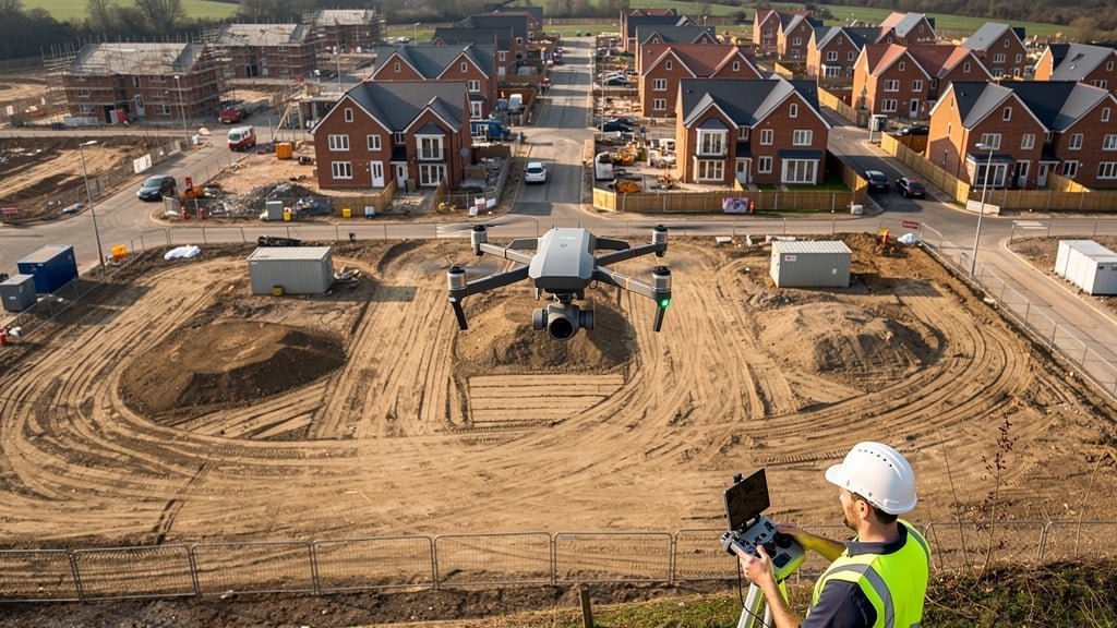
The Hardware
Professional survey drones are sophisticated pieces of equipment far more advanced than consumer drones. They typically feature:
- High-resolution cameras: Often 20+ megapixels, capturing fine detail from altitude
- RTK GPS: Real-Time Kinematic positioning provides centimeter-level accuracy for image location
- Gimbal stabilization: Keeps cameras steady despite wind and drone movement
- Multiple sensors: RGB cameras for visual data, sometimes thermal or multispectral sensors for specialized surveys
- Obstacle avoidance: Sensors that help prevent collisions and enable safe autonomous flight
- Long flight times: Professional drones can fly 30+ minutes per battery, covering large areas
The Survey Process
A typical drone survey follows a structured process. First, professional topographical surveyors establish ground control points—markers with precisely known coordinates placed around the survey site. These ensure the drone survey ties accurately to the Ordnance Survey National Grid and real-world coordinates.
Next, surveyors program a flight plan. Specialized software calculates the optimal flight path to cover the entire site with appropriate image overlap (typically 70-80% overlap between images). This overlap is crucial for creating accurate 3D models.
The drone then flies autonomously, following the predetermined path and automatically capturing hundreds or thousands of images. A large residential development site might be surveyed in 20-30 minutes of flight time, compared to days of traditional fieldwork.
After the flight, the real magic happens in post-processing. Photogrammetry software analyzes all the images, identifying common features between overlapping photos and calculating 3D positions for millions of points across the site. This process, called Structure from Motion, creates a detailed point cloud—a 3D representation of the surveyed area.
From this point cloud, surveyors can generate various deliverables: traditional 2D topographic maps with contour lines and spot levels, detailed CAD drawings showing natural and man-made features, 3D models for visualization, and even accurate volume calculations for earthworks.
Key Advantages of Drone Surveys
Speed and Efficiency
The most obvious advantage is speed. A survey that might take a week using traditional methods can be completed in a day with drones. This dramatically reduces project timelines, helping architects and developers move forward with planning permission applications and construction projects more quickly.
For property buyers needing a topographic survey for land purchase, faster turnaround means less delay in completing transactions. For construction companies, it means less site downtime and reduced costs for survey services.
Safety
Drone surveys eliminate many safety risks inherent in traditional surveying. Surveyors don't need to access steep slopes, cross busy roads, navigate hazardous terrain, or work near dangerous structures. This is particularly valuable for:
- Cliff edges and coastal erosion sites
- Contaminated land or brownfield sites
- Areas with unstable ground
- Sites with ongoing construction activity
- Roofs and tall structures
- Areas with wildlife or environmental sensitivities
Cost-Effectiveness for Large Sites
While drone surveys aren't always cheaper for small sites, they become increasingly cost-effective as site size grows. Traditional survey costs increase roughly linearly with area—doubling the site size roughly doubles the survey time and cost. Drone surveys scale more efficiently, as flying over a larger area doesn't take proportionally more time.
For agricultural land surveys, large development sites, or infrastructure projects covering many acres, drone surveys can cost a fraction of traditional methods while actually providing more comprehensive survey data.
Comprehensive Data Capture
Traditional surveys capture data at discrete points where surveyors set up equipment. Drone surveys capture continuous data across the entire site. This completeness means:
- Nothing is missed—every feature is recorded
- Clients can request additional information from the same dataset without resurveying
- 3D models allow virtual site visits and planning
- High-resolution aerial photography provides context traditional surveys lack
- Subtle features like drainage patterns or ground conditions become visible
Minimal Site Disruption
Traditional surveys require surveyors to physically access all areas of a site, which can disrupt operations, damage sensitive ground, or disturb wildlife. Drone surveys capture most data from above, minimizing site disturbance. This is particularly valuable for:
- Operating industrial or commercial sites where production can't stop
- Agricultural land during growing seasons
- Environmentally sensitive areas
- Heritage sites where physical access must be limited
Applications of Drone Surveys
Planning Permission and Development
Drone surveys are ideal for creating the topographic surveys local authorities require for planning permission applications. The comprehensive data allows architects to design with confidence, understanding every nuance of the site's topography. Detailed 3D models help visualize how proposed developments will fit into existing landscapes.
Construction Site Monitoring
Regular drone surveys throughout a construction project provide progress monitoring, volume calculations for earthworks, and verification that work matches design specifications. Some construction companies conduct weekly or monthly drone surveys to track progress and identify potential issues early.
Infrastructure Inspection
Drones excel at inspecting infrastructure that's difficult or dangerous to access: bridges, towers, roofs, solar farms, and wind turbines. High-resolution imagery captures condition details without scaffolding or cherry pickers.
Flood Risk Assessment
The detailed elevation data from drone surveys is perfect for flood risk assessment. Hydrologists can use the topographic data to model water flow, identify flood-prone areas, and design drainage systems. The visual imagery also helps identify existing watercourses and drainage patterns.
Stockpile and Volume Measurement
Quarries, mines, and construction sites need regular volume measurements of stockpiles. Drone surveys can calculate volumes with high accuracy, far more quickly than traditional methods, and provide documentary evidence through 3D models and reports.
Limitations and Considerations
Weather Dependency
Drone surveys require relatively good weather. Strong winds make flying dangerous or impossible. Rain affects image quality and can damage equipment. Heavy cloud cover creates poor lighting conditions. While traditional surveys can often proceed in marginal weather, drones need better conditions.
Vegetation Challenges
Drones survey from above, meaning they capture what's visible from the sky. Dense vegetation, tree canopy, or tall buildings can obscure ground features underneath. While sophisticated software can sometimes filter out vegetation to reach the ground surface, heavily wooded areas may still require supplementary traditional surveying.
Regulatory Requirements
Professional drone surveying in the UK requires proper licensing and permissions. Surveyors must hold Commercial Drone Pilot licenses and comply with Civil Aviation Authority regulations. Some areas—near airports, in controlled airspace, or over congested areas—require special permissions. Professional survey companies handle these requirements, but they can occasionally cause delays.
Not Always the Answer
For small sites, simple surveys, or areas where access isn't challenging, traditional methods may be equally fast and potentially less expensive. The best survey companies assess each project individually, recommending drone surveys when they offer clear advantages and traditional methods when they're more appropriate.
The Future of Drone Surveying Technology
Drone survey technology continues advancing rapidly. Current developments include:
- LiDAR integration: Laser scanning from drones can penetrate vegetation and provide even more accurate elevation data
- AI processing: Machine learning algorithms increasingly automate feature extraction from drone imagery, identifying buildings, trees, utilities, and other features automatically
- Real-time processing: Some systems now process data on-site, allowing surveyors to verify coverage and quality before leaving
- Longer flight times: Improved batteries and more efficient designs extend surveying sessions
- Better sensors: Higher resolution cameras and additional sensor types provide richer data
- Integration with BIM: Drone survey data feeds directly into Building Information Modeling systems used by architects and engineers
Combining Drone and Traditional Surveys
The best approach often combines drone technology with traditional surveying methods. Professional topographical surveyors use drones to capture overall site conditions quickly, then deploy traditional total stations and GPS equipment for detailed measurements in specific areas or where vegetation obscures the ground surface.
This hybrid approach leverages the strengths of both methods: speed and comprehensive coverage from drones, precision and ability to penetrate vegetation from traditional techniques. For complex sites, this combination delivers superior results compared to either method alone.
Choosing a Drone Survey Provider
When considering drone surveys for your project, look for:
- Proper licensing: Ensure surveyors hold Commercial Drone Pilot licenses and appropriate insurance
- Professional memberships: Look for CIOB, RICS, or RPSA accreditation
- Experience: Ask about similar projects they've completed
- Equipment quality: Professional-grade drones and processing software matter
- Deliverables: Confirm they can provide data in formats your architect or engineer needs
- Support: Good surveyors explain their process and answer questions throughout
Conclusion
Drone survey technology has revolutionized topographic surveying, making it faster, safer, and often more cost-effective than traditional methods alone. For property buyers, developers, architects, and civil engineers, drones provide comprehensive survey data that supports better decision-making throughout the project lifecycle.
However, drones aren't a complete replacement for traditional surveying—they're a powerful addition to the surveyor's toolkit. The best survey companies combine modern drone technology with traditional expertise, choosing the right approach for each project's unique requirements.
As the technology continues advancing and regulations evolve, drone surveys will play an increasingly central role in land surveying across the UK. Whether you're planning a house extension, developing a large site, or need regular construction monitoring, it's worth discussing drone survey options with professional topographical surveyors to see how this technology could benefit your project.
Need Drone Survey Services?
Our survey team uses the latest drone survey technology combined with traditional surveying expertise to deliver accurate topographic surveys across the UK.
Get Started