Flood Risk Assessments: Why Topographic Data Matters for Property Development
Flooding is one of the most significant risks facing property development in the UK, with climate change increasing both the frequency and severity of flood events. Understanding flood risk through accurate topographic survey data isn't just about regulatory compliance—it's about protecting investments, ensuring safety, and making informed decisions about land development. This comprehensive guide explores why topographic data is crucial for flood risk assessment and how professional land surveys support effective flood mitigation strategies.
The Growing Importance of Flood Risk Assessment
Recent years have seen devastating floods across the UK, from severe winter storms to flash flooding from intense summer rainfall. Climate projections suggest these risks will only increase, making flood risk assessment an essential component of property development planning.
Local authorities now scrutinize flood risk carefully in planning permission applications. Properties in flood zones may face planning restrictions, higher insurance costs, or requirements for extensive mitigation measures. Understanding your site's flood risk before purchasing land or submitting planning applications can save developers from costly surprises and potential project failures.
Topographic surveys provide the foundational data for flood risk assessment, offering precise elevation information that determines how water flows across and around your site. Without accurate topographic data, flood risk cannot be properly assessed or managed.
How Topographic Surveys Support Flood Risk Assessment
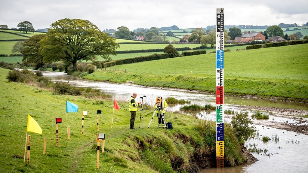
Elevation Data: The Foundation of Flood Analysis
The most critical contribution of topographic surveys to flood risk assessment is precise elevation data. Professional topographical surveyors use accurate GPS equipment and total stations to measure spot levels and create detailed contour maps showing the elevation of the land across your entire site.
This elevation data reveals which areas are naturally low-lying and potentially vulnerable to flooding. Even small differences in ground level—perhaps just a few centimeters—can determine whether an area floods during storm events. Traditional methods of visual assessment often miss these subtle variations that topographic surveys capture precisely.
Spot levels at key points—building locations, access routes, drainage features—provide the specific measurements needed for detailed flood modeling. Engineers use this data to predict water depths, flow velocities, and flood extents under different scenarios.
Understanding Site Drainage Patterns
Topographic surveys show natural and man-made features that affect drainage: slopes, valleys, ridges, watercourses, ditches, and existing drainage infrastructure. Contour lines on topographic maps clearly illustrate how water naturally flows across the site, revealing potential flow paths during flood events.
Surface water naturally follows the path of least resistance, flowing from higher to lower ground and concentrating in valleys and depressions. A topographic survey identifies these natural drainage paths, showing where water accumulates and how it exits the site. This information is essential for designing effective drainage systems and positioning buildings to avoid natural water flow routes.
Existing drainage features—manholes, gullies, culverts, ponds—are mapped during the survey with their invert levels (the level at which water enters) recorded. This data helps engineers understand current drainage capacity and identify potential bottlenecks that could cause flooding.
Relationship to Surrounding Land and Watercourses
Flood risk doesn't stop at property boundaries. A comprehensive topographic land survey extends beyond your site to show surrounding topography, nearby watercourses, and potential off-site drainage affecting your property.
If your site sits lower than surrounding land, you may be vulnerable to surface water runoff from neighboring properties. If you're near rivers, streams, or drainage channels, the survey shows your site's elevation relative to these water features—crucial for assessing fluvial (river) flooding risk.
The survey also reveals whether your site might contribute to downstream flooding. Responsible development requires demonstrating that your proposals won't increase flood risk elsewhere, something that can only be proven with accurate topographic data.
Types of Flooding and Topographic Data Requirements
Fluvial Flooding (River Flooding)
Fluvial flooding occurs when rivers overtop their banks or breach flood defenses. For sites near watercourses, topographic surveys must show:
- Precise elevations relative to river levels and known flood levels
- Distance from watercourses and flood defenses
- Natural flood plains and low-lying areas
- Ground levels at potential access points that might be cut off during floods
Flood risk specialists use survey data combined with historical flood levels and hydraulic modeling to predict how high water might reach during different flood return periods (1 in 100 year events, 1 in 1000 year events, etc.).
Surface Water Flooding (Pluvial Flooding)
Surface water flooding results from intense rainfall overwhelming drainage systems or collecting in low areas. This type of flooding has become increasingly common with more frequent extreme weather events and expanding development reducing natural drainage.
Topographic surveys identify surface water flood risk by showing:
- Depressions and low spots where water accumulates
- Natural flow paths that channel water across the site
- Existing drainage infrastructure capacity
- Slopes that might direct water toward buildings or infrastructure
For surface water flooding, even subtle topographic variations matter. A building positioned just 0.3 meters higher than surrounding ground might avoid flooding that affects lower areas. Topographic surveys capture these crucial details.
Groundwater Flooding
Groundwater flooding occurs when water tables rise to the surface, typically in low-lying areas with particular geological conditions. While topographic surveys don't directly measure groundwater levels, they identify low-lying areas where groundwater flooding is more likely and provide elevation data for comparing to known groundwater levels.
Coastal and Tidal Flooding
For coastal developments, topographic surveys show elevations relative to tide levels and storm surge heights. The survey must extend to show the relationship between the site and sea defenses, beaches, or other coastal features that affect flood risk.
Planning Permission and Regulatory Requirements
Environment Agency Flood Zones
The Environment Agency maintains flood zone maps classifying areas based on flood probability. Developments in Flood Zone 2 (medium risk) or Flood Zone 3 (high risk) face additional planning requirements, including mandatory flood risk assessments.
Even sites in Flood Zone 1 (low risk) may require flood risk assessment if they're large (over 1 hectare) or in areas with surface water flood risk. Topographic survey data is essential for all these assessments, providing the accurate elevation information regulators need to evaluate flood risk properly.
Sequential Test and Exception Test
Planning policy requires demonstrating that development is located in areas of lowest flood risk where possible (Sequential Test). For developments in higher-risk areas, an Exception Test must prove wider sustainability benefits and show the development will be safe without increasing flood risk elsewhere.
Both tests require detailed understanding of site topography. You can't demonstrate a site is suitable for development without accurate topographic data showing exactly how flood risk can be managed through careful positioning, drainage design, and mitigation measures.
Sustainable Drainage Systems (SuDS)
Modern planning requirements mandate Sustainable Drainage Systems to manage surface water, mimicking natural drainage rather than simply piping water away. Effective SuDS design is impossible without accurate topographic data showing natural flow paths, gradients, and opportunities for features like swales, detention basins, and permeable surfaces.
The topographic survey provides the baseline for SuDS design, showing where water naturally wants to go and how the existing topography can be worked with rather than against.
Practical Applications in Development Projects
Site Selection and Land Purchase
Smart property buyers commission topographic surveys before purchasing land, especially in areas with potential flood concerns. The survey reveals flood risk factors that might not be apparent during site visits:
- Is the site in a natural depression that could collect water?
- How does site elevation compare to surrounding land?
- Are there existing drainage routes that might affect development?
- What is the relationship to nearby watercourses?
Understanding these factors early prevents purchasing land that proves undevelopable due to flood risk, or allows negotiating purchase price to account for flood mitigation costs.
Building Positioning and Floor Levels
Topographic data guides crucial decisions about where to position buildings and what finished floor levels to specify. Architects use survey data to:
- Position buildings on higher ground where possible
- Set floor levels above known flood levels with appropriate freeboard
- Design ground levels and landscaping to direct water away from buildings
- Minimize earthworks by working with natural topography
Sometimes raising buildings just 0.5 meters above surrounding ground eliminates flood risk entirely. The topographic survey provides the elevation data needed to make these informed decisions.
Drainage Design
Effective drainage design depends entirely on accurate topographic data. Engineers need to know:
- Existing ground levels to calculate required drainage falls
- Natural flow paths to work with gravity
- Locations of existing drainage infrastructure and their capacities
- Outfall points and their levels relative to the site
Drainage systems must have sufficient gradient (fall) to function properly—typically minimum 1:80 for foul drainage and 1:100 for surface water. Without accurate spot levels from topographic surveys, drainage designs may fail to achieve required falls, leading to blockages, surcharging, and potential flooding.
Access and Evacuation Planning
Safe access is crucial during flood events, both for evacuation and emergency services. Topographic surveys show whether access routes are on higher ground that remains passable during flooding, or if they pass through vulnerable low-lying areas that could be cut off.
For developments in flood-prone areas, demonstrating safe access and egress routes during flood events is a planning requirement. This is only possible with accurate elevation data from topographic surveys.
Flood Mitigation Strategies Informed by Topographic Data
Compensatory Storage
When development reduces flood plain storage capacity, compensatory storage must be provided elsewhere to maintain overall flood storage volume. Designing compensatory storage requires detailed topographic data to calculate volumes accurately and ensure new storage areas are at appropriate elevations to function effectively.
Flood Defenses and Barriers
Whether permanent defenses like earth bunds or temporary flood barriers, effective flood protection requires knowing exact ground levels. The topographic survey shows where defenses are needed and at what height they must be built to provide the required protection level.
Landscaping and Levels
Careful manipulation of ground levels can significantly improve flood resilience. Topographic data guides landscaping design that directs water away from buildings, creates positive drainage to outfalls, and ensures paved areas don't create new surface water flow paths that increase flood risk.
Case Study Examples
Residential Development Near River
A developer planning houses near a river commissioned a comprehensive topographic survey extending to the riverbank. The survey revealed the site's lowest point was actually 1.2 meters above the 1 in 100 year flood level, proving the site was suitable for development. Without this precise topographic data, the project might have been refused planning permission or required expensive unnecessary flood defenses.
Commercial Building with Surface Water Issues
An architect designing a commercial building on a sloping site used topographic survey data to identify a natural flow path where surface water concentrated during heavy rain. Rather than fighting this, the design incorporated a landscaped swale along this route, managing surface water sustainably while adding an attractive landscape feature. The topographic data made this elegant solution possible.
Housing Development and SuDS
A housing developer used detailed topographic survey data to design a sustainable drainage system working with the site's natural topography. Detention basins were positioned in existing low areas, swales followed natural valleys, and permeable paving was used on flatter areas. The result was a SuDS system that cost 30% less than a conventional piped system while providing better flood protection and ecological benefits.
The Cost of Inadequate Topographic Data
Attempting flood risk assessment without proper topographic surveys leads to expensive problems. Property buyers have purchased land only to discover it's effectively undevelopable due to flood risk. Developments have been designed with inadequate floor levels, requiring expensive redesign or resulting in buildings that flood. Drainage systems have been installed at incorrect levels, failing to function and requiring costly remedial work.
The cost of a professional topographic survey is tiny compared to these potential losses. It's an essential investment in understanding your site properly and making informed decisions about flood risk.
Conclusion
Topographic survey data is not optional for proper flood risk assessment—it's fundamental. Whether you're a property buyer assessing land, an architect designing flood-resilient buildings, or a developer planning drainage systems, accurate elevation data from professional topographical surveyors provides the foundation for all flood-related decisions.
Climate change is making flood risk increasingly important in property development. Sites that were safe a generation ago may now be vulnerable. Understanding flood risk through comprehensive topographic surveys protects your investment, ensures regulatory compliance, and most importantly, protects future occupants from flood damage.
Don't approach flood risk assessment as merely a regulatory hurdle. See it as an opportunity to understand your site deeply and design development that works with natural water flows rather than against them. With accurate topographic data from experienced land surveyors, you can confidently assess flood risk, implement effective mitigation, and create development that's resilient to flooding now and in the future.
Need Topographic Survey for Flood Risk Assessment?
Our professional topographical surveyors provide accurate elevation data and detailed topographic maps essential for flood risk assessment and drainage design across the UK.
Learn More