Understanding CAD Drawings: How to Read Topographic Survey Plans
CAD drawings are the language of construction and development, yet many property owners, developers, and even some professionals find them intimidating at first glance. Understanding how to read topographic survey plans is a crucial skill that can save time, prevent costly mistakes, and help you communicate effectively with architects, engineers, and planning authorities. This comprehensive guide explains everything you need to know about interpreting CAD drawings from topographic surveys.
What Are CAD Drawings?
CAD stands for Computer-Aided Design, though in surveying contexts, it's more accurately Computer-Aided Drafting. Professional topographical surveyors use specialized CAD software to create precise digital drawings from survey data collected in the field using GPS equipment, total stations, and other surveying technology.
Unlike simple sketches or photographs, CAD drawings are mathematically accurate representations of the site. Every point, line, and feature is positioned with millimeter precision, tied to real-world coordinates. This accuracy makes CAD drawings the foundation for architectural design, planning permission applications, and construction work.
Modern CAD drawings are typically delivered in both PDF format for viewing and printing, and in native CAD formats (DWG or DXF files) that architects and engineers can work with directly. The native formats allow designers to import survey data into their own CAD systems, ensuring their designs are based on accurate land data.
The Basic Components of Topographic Survey Drawings
Title Block and Information Panel
Every professional CAD drawing includes a title block, usually positioned in the bottom right corner. This contains essential information:
- Project name and address: Identifies the surveyed site
- Survey company details: Name, contact information, and professional accreditations (RICS, CIOB, RPSA)
- Drawing number: For projects with multiple sheets
- Date of survey: When the field survey was conducted
- Scale: Typically shown as a ratio (e.g., 1:200) and often with a scale bar
- Coordinate system: Usually British National Grid (Ordnance Survey)
- Datum: The reference level for height measurements, often Ordnance Datum Newlyn
- Revision history: Any updates or amendments made to the drawing
Border and Scale
The drawing border defines the extent of the surveyed area. The scale indicates how much the real world has been reduced to fit on the drawing. A 1:200 scale means one unit on the drawing represents 200 units in reality—so 1cm on the drawing equals 200cm (2 meters) on the ground.
Common scales for topographic surveys include 1:50 for detailed areas, 1:100 or 1:200 for residential plots, and 1:500 or 1:1000 for larger sites. The scale bar provides a visual reference that remains accurate even if the drawing is printed at different sizes.
Legend or Key
The legend explains symbols and abbreviations used throughout the drawing. While many symbols follow industry standards, surveyors may use specific conventions, so always refer to the provided legend. Common symbols include different line types for boundaries, fences, walls, and services.
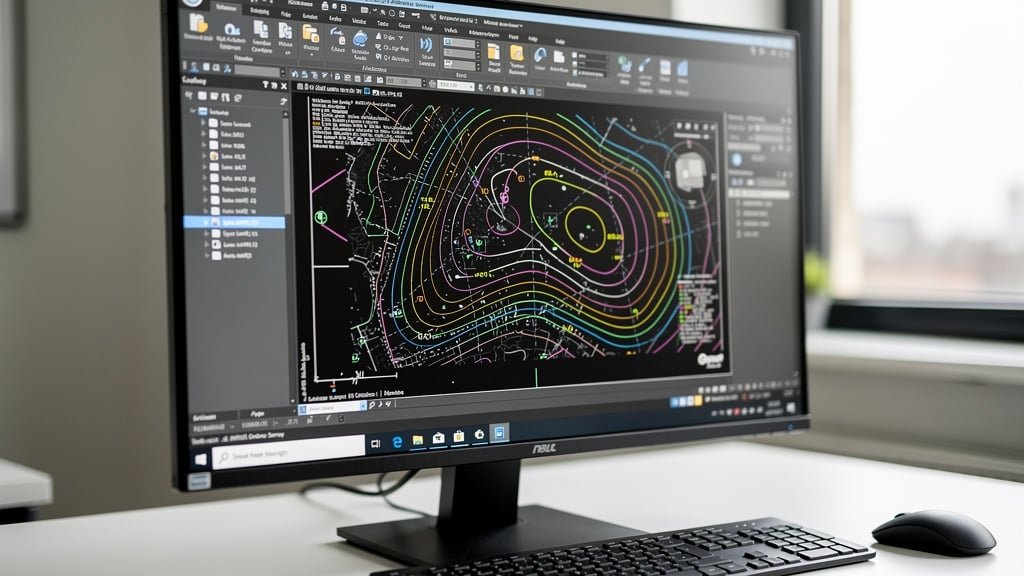
Understanding Contour Lines
Contour lines are perhaps the most important yet most misunderstood feature of topographic survey drawings. These lines connect points of equal elevation, creating a map of the land's three-dimensional shape in two dimensions.
How to Read Contours
Each contour line represents a specific height above the datum. If contours are shown at 0.5m intervals, each line represents ground that is exactly 0.5 meters higher (or lower) than the adjacent line. The elevation is typically marked on the contour line itself or in breaks in the line.
Close together contours indicate steep slopes—the closer the lines, the steeper the gradient. Widely spaced contours show gentle slopes or relatively flat ground. Contour lines never cross each other (except in rare cases like overhanging cliffs) because a point can only be at one elevation.
The direction of slope can be determined by reading the contour values. Ground slopes from higher numbered contours toward lower numbered ones. Some drawings include "hachures"—short perpendicular lines—pointing downhill to clarify slope direction.
Interpreting Terrain from Contours
Contour patterns reveal terrain features:
- Concentric circles with higher values inside: Hills or mounds
- Concentric circles with lower values inside: Depressions or hollows
- V-shapes pointing uphill: Valleys or drainage lines
- V-shapes pointing downhill: Ridges or high ground
- Parallel lines: Uniform slopes
- Irregular spacing: Uneven or complex terrain
Understanding these patterns helps you visualize the site in three dimensions and anticipate drainage, access, and foundation challenges before visiting the site.
Spot Levels: Precise Height Information
While contours show general terrain, spot levels provide exact elevations at specific points. Shown as numbers with a small cross or point marker, spot levels are crucial for precise design work.
Spot levels are typically positioned at:
- Building corners and key features
- Road and path edges
- Drainage features and manholes
- Significant changes in gradient
- Site access points
- Boundary corners
The spot level format typically shows the height in meters to three decimal places (e.g., 45.123m), though some surveyors round to two decimal places for general features. The precision reflects the accuracy of modern surveying technology.
When planning construction, architects use spot levels to calculate exact ground levels for foundations, drainage falls, and finished floor levels. The difference between spot levels at various points indicates the slope or fall across the site.
Reading Symbols and Features
Boundaries and Fences
Property boundaries are typically shown with thick lines, often with additional notation indicating the boundary type. Legal boundaries may differ from physical features, so CAD drawings usually distinguish between:
- Thick black lines: Property boundaries
- Dashed lines: Assumed or approximate boundaries
- Various symbols: Fences (timber post and rail, chain link, etc.), walls (brick, stone, retaining), and hedges
Understanding boundary representations is crucial for planning applications and building near property lines, where regulations often specify minimum distances from boundaries.
Buildings and Structures
Buildings are usually shown as solid shapes with outlines indicating walls. The drawing may show:
- Building footprints with dimensions
- Roof overhangs (shown with dashed lines)
- Door and window positions
- Material notations (brick, stone, timber, etc.)
- Height information at eaves and ridges
Smaller structures like sheds, garages, and outbuildings are depicted similarly, often with labels identifying their purpose and materials.
Trees and Vegetation
Trees are typically shown as circles representing canopy spread, with symbols indicating whether they're deciduous or evergreen. Professional surveys often include:
- Tree reference numbers
- Species identification
- Trunk diameter measurements
- Approximate height
- Crown spread
- Condition notes
This information is particularly important when trees have preservation orders or when planning development near significant trees, as root protection zones must be considered.
Hedges, shrubs, and general vegetation are shown with different symbols, often with hatching or specific patterns indicating vegetation type and density.
Hard Surfacing and Paths
Roads, driveways, paths, and paved areas are clearly delineated with outlines and often labeled with surface material (tarmac, concrete, gravel, paving, etc.). Spot levels along path edges help designers understand existing drainage patterns and gradients.
Drainage and Services
Visible drainage features are crucial elements of topographic surveys:
- Manholes and inspection covers: Usually shown as small rectangles or circles with a cross, labeled with rim level and invert level (the level at which drains enter the chamber)
- Gullies: Surface water drainage points
- Direction of flow: Arrows indicating water flow direction in drains
- Ditches and watercourses: Natural drainage features with flow direction
- Other visible services: Telegraph poles, electricity posts, lamp standards
Note that surveyors can only show visible services. Underground utilities require specialist detection surveys, though surveyors may note obvious service routes from visible surface indicators.
Coordinate Systems and Grid References
Professional CAD drawings use coordinate systems to position every feature accurately in space. In the UK, the British National Grid (Ordnance Survey) is standard, with coordinates given as Eastings (horizontal) and Northings (vertical) in meters.
A typical coordinate might be: E 523456.789, N 178234.567. The grid reference allows the site to be located precisely on Ordnance Survey maps and ensures different surveys or designs can be accurately related to each other.
Some drawings include local grid systems for convenience, with simpler coordinates making the drawing easier to work with while maintaining a relationship to the national grid through transformation parameters noted in the title block.
Layer Systems in Digital CAD Files
When you receive CAD files in DWG or DXF format, the drawing is organized into layers—think of them as transparent overlays, each containing related features. Common layer organizations include:
- Topographic features: Ground levels, contours, spot levels
- Buildings: Existing structures
- Boundaries: Property lines and fences
- Vegetation: Trees, hedges, and landscape features
- Services: Drainage and utilities
- Text and labels: Annotations and dimensions
Layers can be turned on or off, allowing you to view only the information relevant to your current task. This is particularly useful when the drawing is complex—you might hide vegetation layers to see underlying topography more clearly, or hide buildings to focus on site boundaries.
Architects importing survey data into their designs use layers to control which survey information appears in their drawings, ensuring clarity without visual clutter.
Common Mistakes When Reading CAD Drawings
Assuming Level Ground
One of the most common errors is assuming areas without contours are perfectly flat. Even small level differences can be significant for drainage and construction. Always check spot levels to understand true gradients.
Misreading Scale
Using the wrong scale when measuring from drawings leads to significant errors. Always verify the scale before taking measurements, and use the scale bar rather than relying on printed paper size, which can vary.
Ignoring the Legend
Assuming you know what symbols mean without checking the legend can lead to misinterpretation. Surveying conventions vary, so always refer to the specific drawing's legend.
Overlooking Date and Revision Information
Using outdated surveys is a frequent problem. Sites change—trees are removed, buildings demolished, ground levels altered. Always verify you're working with the most recent survey and note the survey date when making decisions.
Confusing Contours with Boundaries
Contour lines and boundary lines can sometimes appear similar, particularly if viewing poor quality prints. Check line types carefully and refer to the legend to distinguish between elevation data and property boundaries.
Practical Applications for Different Users
For Property Buyers
Understanding topographic surveys helps property buyers assess land suitability before purchase. Check for:
- Drainage patterns—does water flow toward or away from buildings?
- Access gradients—are slopes manageable for vehicles?
- Development potential—is there level ground for extensions?
- Boundary clarity—are property lines clearly defined?
- Flood risk indicators—are there watercourses or low spots?
For Architects and Designers
Architects use CAD survey data as the foundation for all design work. Key uses include:
- Setting building levels to match existing ground
- Designing drainage that works with natural slopes
- Positioning buildings to minimize earthworks
- Preserving significant trees and features
- Creating accurate site plans for planning permission
- Calculating volumes for earthworks
For Developers and Contractors
Construction professionals use survey drawings for:
- Estimating earthwork costs accurately
- Planning site access and construction logistics
- Identifying existing services that must be protected or diverted
- Setting out new buildings accurately from survey control points
- Checking as-built levels against design intentions
Working With Your Surveyor and Architect
When you receive CAD drawings from your surveyor, don't hesitate to ask questions. Professional land surveyors expect to explain their drawings and can clarify any uncertainties. Common questions include:
- What do specific symbols or annotations mean?
- Are there any unusual features or concerns identified during the survey?
- What accuracy can be expected for different elements?
- Are there any areas that couldn't be fully surveyed due to access or vegetation?
- How should the data be best used for your specific project?
When sharing survey drawings with architects, provide both PDF and native CAD formats. The PDF allows easy viewing and printing, while the CAD file enables them to import accurate data directly into their design software.
Digital Tools for Viewing CAD Drawings
While professional CAD software can be expensive, free viewers are available for opening and examining DWG and DXF files. These viewers allow you to:
- Pan and zoom around the drawing
- Measure distances and areas
- Turn layers on and off
- Print specific views
- Convert to PDF format
Popular free CAD viewers include DWG TrueView from Autodesk and various online viewers that work in web browsers. These tools help you explore survey data without investing in full CAD software.
Conclusion
Understanding CAD drawings from topographic surveys is a learnable skill that becomes easier with practice. While the symbols, contours, and technical information might seem daunting initially, each element serves a specific purpose in communicating accurate land data.
Whether you're a property buyer assessing a potential purchase, an architect designing a new building, or a developer planning a construction project, the ability to read and interpret topographic survey plans saves time, prevents misunderstandings, and helps you make informed decisions.
Remember that professional topographical surveyors are your resource for understanding their drawings. When commissioning a survey, discuss your specific needs so the surveyor can ensure the CAD drawings include all the information your project requires. With the right survey data presented clearly in CAD format, your project has the solid foundation it needs for success.
Take time to study your survey drawings carefully, refer to the legend, and don't hesitate to ask questions. The more you work with topographic surveys, the more valuable you'll find this detailed snapshot of your site becomes—a document you'll reference throughout your project from initial design through to final construction.
Need Professional Topographic Survey CAD Drawings?
Our experienced surveyors provide detailed, accurate CAD drawings that architects and engineers can work with confidently. We're happy to explain your survey drawings and ensure you understand all the information they contain.
Contact Us